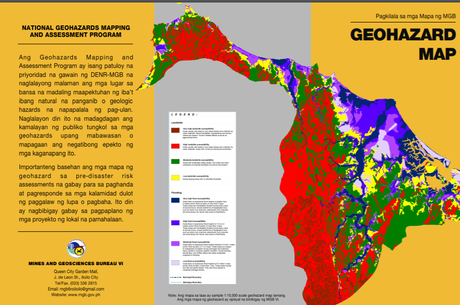
The geologic hazard maps produced by the Mines and Geosciences Bureau (MGB) in the past years contain vital information on the susceptibility of a certain locality to geologic hazards specifically landslide and floods that fall within the scope of MGB’s program.
It is a fact that there may be existing structures built and communities situated in areas that are prone to landslide and flooding, a fact long before the geologic hazard mapping program of MGB commenced in 2005.
Past major landslides such as the Cherry Hills incident in Metro Manila in 1999 caused devastation, loss of lives and social and economic costs.
Recognizing the need for ample information on the geologic status of an area prompted the DENR to issue Department Administrative Order No. 2000-28 on April 25, 2000 mandating that an engineering, geological and geohazard assessment (EGGA) be required prior to the approval of an Environmental Compliance Certificate (ECC) for subdivision, housing and other land development and infrastructure projects.
Following these events, the DENR through the Mines and Geosciences Bureau embarked on a rapid geohazard mapping and assessment nationwide from 2005 to 2010 (1:50,000 scale) and a detailed mapping from 2011 to 2014 (1:10,000 scale).
When MGB completed the production of geohazard maps in 2014, all MGB Regional Offices went on a massive distribution of the maps, prioritizing all the local government units (from the barangays, municipalities, and cities to provinces).
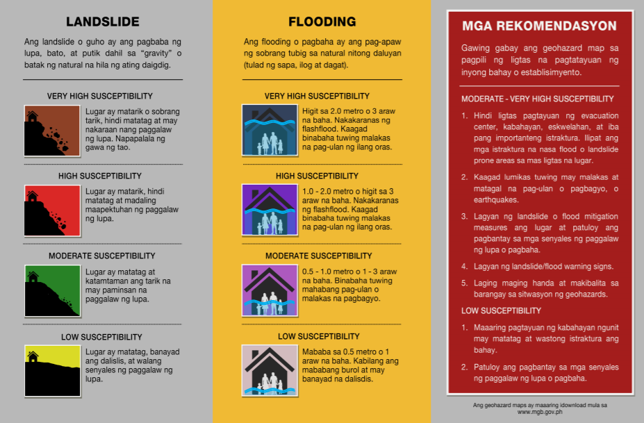
The purpose of the geohazard maps is to inform the end-users on the susceptibility of their areas to landslide and flooding, thus, the potential risks to communities.
To capacitate the local government on understanding and using the geohazard maps, MGB conducted an information and education campaign in each LGU from 2012 onwards. In the IEC conducted in the barangays, for example, MGB adopted a participatory approach where participants in the workshop draw their barangay map, identify the areas prone to landslide and flood, and color these geohazard prone areas based on the color code of the MGB geohazard maps. MGB has presented and explained the use of geohazard maps in the many fora, trainings, workshops, and lectures hosted by different national government agencies and schools in the past years.
In each mapping activity, the MGB field team immediately met with barangay officials after concluding the mapping in their barangay to present the results. As part of the fieldwork procedure, MGB issues the applicable geohazard threat advisories before leaving the barangay for early warning. Subsequently, MGB gives a summary report to the municipal or city chief executives indicating the geohazard findings in all the barangays within their jurisdiction during the exit conference with the local chief executive or his officer-in-charge. The help of the DRRM officers in coordinating and data gathering is worth noting in the conduct of the geohazard mapping and assessment.
When heeded, the information provided by the geohazard maps can help achieve the purpose of reducing the possible disaster that may happen when landslide and flooding occur in an area. Along this line, MGB documented a community’s appreciation and application of the geohazard map based on the experience of Barangay Cawilihan, in the Municipality of Leon, Iloilo when a landslide affected the barangay in August 2011.
MGB investigated a landslide reported by Brgy. Cawilihan on August 27, 2011 from the strong and continuous monsoon rains triggered by Typhoon “Mina”. An earthquake that occurred in the prior days further triggered the landslide. MGB documented that the Landslide Threat Advisory it issued was posted on the Barangay’s bulletin board.
According to then Punong Barangay Hans Rodriguez of Brgy. Cawilihan, the landslide area is about twenty hectares and moved downslope every two seconds. The landslide totally damaged eight houses, rendered twenty hectares of farmland unfit for production, and caused the collapse of more or less fifty meters long of the barangay road. It affected eleven families composed of fifty-one individuals.
The good news was that there were no casualties in barangay Cawilihan despite the severity and extent of the landslide because the residents were able to evacuate and removed their belongings from their houses before the landslide hit the area.
Educating people especially on the technicalities of government programs such as geohazard mapping is not an easy task. However, MGB believes that the years of field assessments reaching the remotest Sitios and barangays and the interactions with people created a two-way learning process. MGB personnel imparted their knowledge firsthand to communities just by talking and interviewing them during the assessments. The printed advisories, maps and reports are concrete proofs of what has been gathered and learned. MGB, in all its capacities and limitations, started educating people on the importance of using concrete information to achieve a greater purpose of saving lives. Although this may not have been unequivocally successful, the Barangay Cawilihan experience would attest that when heeded, early warning such as from a Landslide Threat Advisory can save lives.
Geohazard mapping is only a part of the whole disaster risk reduction and management work. MGB, for its part, has always been an active member and source of information in the Regional Disaster Risk Reduction and Management Council (RDRRMC) spearheaded by the Office of the Civil Defense (OCD). In reaching out to the local government, MGB works hand-in-hand with the Department of the Interior and Local Government (DILG) in all its DRRM efforts.
The geohazard map is useful not only to locate disaster-prone areas but also to identify relocation sites and provide inputs in the preparation and updating of the local government’s Comprehensive Land Use Plans (CLUPs). Hence, it is not just a disaster area predictive tool but also a guide to safety. (MGB-6)