
Iloilo City – The Mines and Geosciences Bureau (MGB) VI, Department of Environment and Natural Resources (DENR) reported that it has conducted vulnerability risk assessment in 82 municipalities and cities of Region 6 from 2015 up to the present. This is according to a report of MGB VI as input to the review of the Typhoon Odette Recovery and Rehabilitation Plan – Investment Program (RRP-IP) which the National Economic and Development Authority (NEDA) is spearheading.
The total number of VRAs conducted by MGB comprises 62% of the total number of localities that will be subject to the assessment.
The VRA is a continuation of the government’s National Geohazard Mapping Program that the DENR-MGB completed in 2014. MGB produced detailed geohazard maps on a scale of 1:10,000 of all municipalities in the region indicating the level of susceptibility of barangays and sitios to landslides and flooding. The map gives information on how susceptible a particular location is to these natural hazards. Local planners and managers have used the geohazard maps as guide in planning, identifying safe areas for building, evacuation sites, and development, and formulating mitigation and disaster management programs towards more resilient communities.
In 2015, the MGB embarked on conducting vulnerability risk assessment, which is a more expansive look at risk exposures of areas. Ms. Mae Magarzo, chief of the Geosciences Division explained that the VRA is an assessment of the degree of vulnerability and potential risks of an area given the exposure of these three elements, population, built-up areas and roads, to rain-induced landslides and floods. With this data, the VRA produces predictive information on the number of population, extent of built-up areas, and roads that would be affected given their exposure to the varying levels of vulnerability, in the occurrence of landslides and flooding in these areas.
Given our country’s vulnerability to natural hazards, the MGB will continue to prioritize programs and activities that will provide information based on science, research and actual field assessments that helps build our capacities and readiness every time a typhoon or other natural conditions affect our country, MGB VI OIC Regional Director Raul A. Laput said.
We are more than halfway in completing the VRA of all municipalities in Region 6, but our pacing slowed down when force majeure due to the COVID 19 pandemic, we had to reduce our fieldwork targets, but we did not stop, Ms. Magarzo. Aside from the VRA, MGB also works on coastal hazard assessment, karst subsidence hazard or sinkhole mapping, and groundwater resource assessment under the Geological Risk Reduction and Resiliency Program of MGB.
We also go beyond conducting these assessments. We are working hand in hand with the national government agencies and local government in making information more readily accessible for all, and continue raising the level of awareness of people on what to do when faced with natural hazards, which in reality, is on a regular frequency every year. Our aim always is to save lives, and we just have to keep building up our efforts for preparedness, response and recovery, OIC RD Raul Laput says. (MGB VI)
-
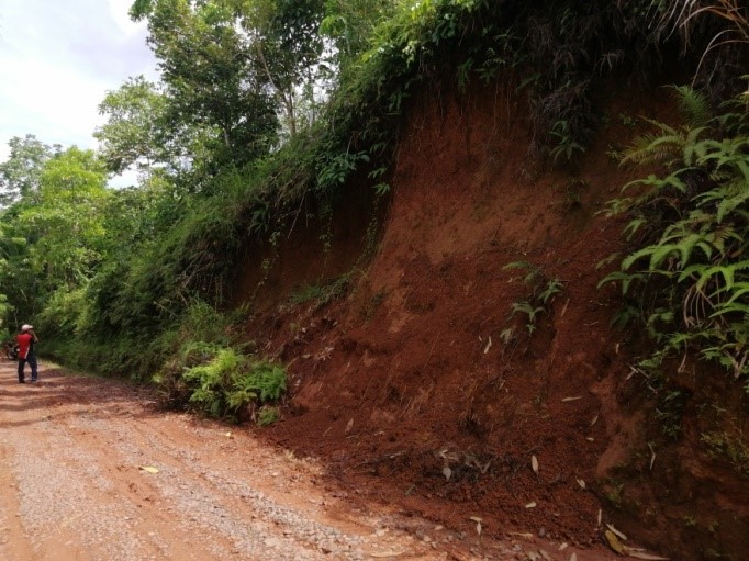
- Steep roadcuts were observed along a road segment in Purok Camarin, Brgy. Malocloc Norte, Ivisan, Capiz with moderate to steep slopes. The road is prone to mass movement, and the area is classified as having moderate to high landslide susceptibility.
-
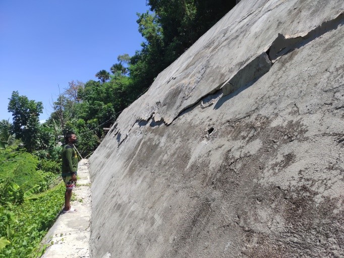
- A damaged segment of a slope protection in Purok Marangkalan, Brgy. Basiao, Ivisan, Capiz with moderate to steep slopes. The slope protection was damaged due to the lack of drainage system and oversaturation of soil along the road. The area is classified as moderate to high on landslide susceptibility.